Go Island Hopping on Skanderborg Sø
Skanderborg Lake contains a total of four small islands, each with its own history. Read about them here and see how you can go on a very special island hopping.
You can get around Skanderborg Lake by canoe. Rent one, for example, at Danhostel Skanderborg or Skanderborg Sø Camping.
Æbelø
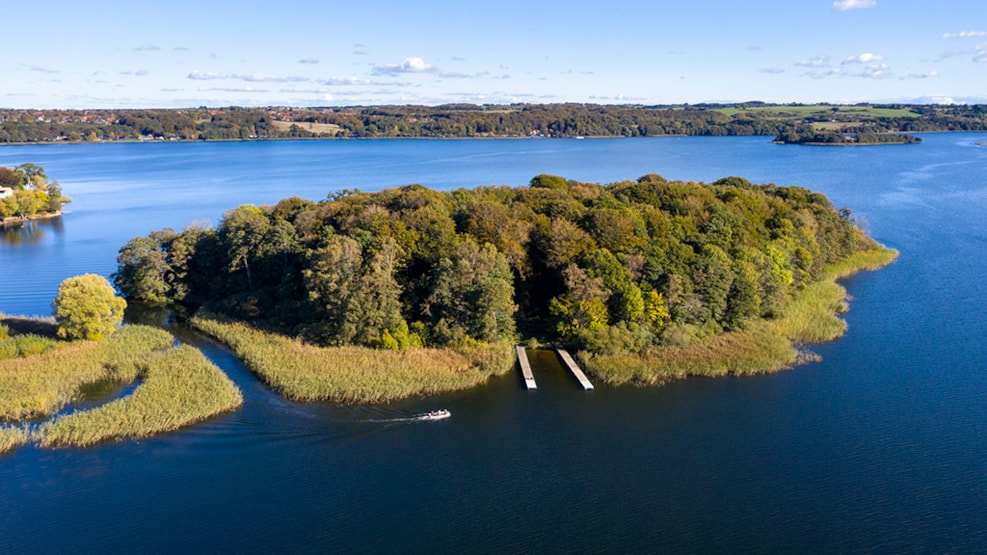
Æbelø is one of the four islands located in Skanderborg Lake. The island has been a popular excursion destination for several hundred years and is mentioned several times in Danish history.
It is uncertain how Æbelø got its name. Some say the name comes from an old grove of wild apple trees, while others claim the name comes from an old word meaning "vaulted" or "round-like," which matches the island's shape.
The historical Æbelø
Exciting discoveries have been made on the island throughout history, dating back to the Stone Age. The island is also mentioned in one of St. St. Blicher's poems, where he writes about young Prince Christian. In 1617, Æbelø is mentioned again, this time by the now-adult King Christian IV in his letters, where he orders the bailiff to set up a boathouse, fish house, and two huts on Æbelø. It can be concluded that there was already a lot of fishing in Skanderborg Lake at that time.
In 1810, a bathhouse was erected, and visitors could buy tickets to use it. Paths were cleared so people could take a walk along the shore, and a dance area was created for people to dance on. In the summer, the island was a popular excursion destination for the city's citizens, who took the boat, which sailed in a regular schedule.
In 1855, Skanderborg town bought Æbelø, the rural estate Sølund, and the entire Dyrehaven for the tidy sum of DKK 120,000. Eighty years later, in 1935, the water level in the lake was lowered, so Æbelø is only separated from the mainland by a narrow channel to this day.
Kalvø and Fåreø
Although two islands are mentioned here, they are now considered one island located in Skanderborg Lake.
Kalvø has been used for grazing for centuries and most likely got its name because calves used to graze on the island. Today, the island is 4.4 hectares. In the past, the smaller island of Fåreø lay south of Kalvø, but when the water level in Skanderborg Lake was lowered in 1932 to prevent agricultural land from being flooded during thaw, Fåreø became land-connected with Kalvø.
Today, Kalvø is deserted, free of cattle and sheep. The island is a popular excursion destination for boaters who often bring a picnic basket to the island. There is a good fishing life in the lake and good goose and duck hunting during their migration over the island.
On Kalvø, a number of stone tools have been found, indicating that there were settlements on the island in the Stone Age. In the first half of the 12th century, a group of Benedictine monks (black brothers) built a monastery and a small harbor on the northeastern part of the island. There were probably around 12 monks and an abbot living here until there were only two monks left in 1168.
In the same year, the monastery was taken over by Cistercian monks (Gray Friars), who had been searching for a suitable place to live in the Aarhus Diocese for several years. The monks built huts on the island, but after only four years on the island, they had to give up because the weather often prevented the crossing to and from the island for days or even weeks. Therefore, in 1172, they moved to Øm between Mossø and Gudensø, and founded Øm Monastery, which was demolished in 1561. Today, the area around the former monastery has been converted into a museum where one can get an insight into the daily life of the monks.
Sct. Thomas
The island is located at the northern end of Skanderborg Lake and was created by Master Baker Thomas Brædstrup, who died in 1877. In addition to being named after its creator, the island's name is a greeting to Saint Thomas Island in the Caribbean Sea.
In the early 1800s, Master Baker Thomas was responsible for building several houses on Skanderborg's main street, Adelgade. Therefore, he often had excess soil from the many excavations, which resulted in Thomas getting an idea to throw the soil into Skanderborg Lake.
For several years, during cold winters, Thomas instructed his people to drive horse-drawn carriages and wheelbarrows with soil and stones out onto the thick ice. When spring came, the large piles of dirt disappeared, and everything was as usual. The trick of disposing of excess soil continued for several years, and eventually, so much soil had been thrown into the lake that a small island appeared above the surface of the water. The island was, of course, very small at first, but with the water level lowering in 1912 and 1932, it grew significantly in size.
Today, the island is privately owned and fully planted, so it sits in the lake like a small green spot.
Sct. Helene
As the smallest of the four islands in Skanderborg Lake, Sct. Helene is located at the western end, well hidden behind the railway embankment. According to legend, the island was created as a result of a large landslide on the railway embankment. This is based on the fact that Nybro was expanded in 1923, and in the night, the embankment collapsed. The next morning, a small island did indeed emerge, but after a few days, it disappeared again.
Sct. Helene was already there, and remains from the younger Stone Age have also been found on the island. On a map of the Skanderborg Rytterdistrict from 1723, the island was called Bollers Ø. Where this name comes from is unknown. The explanation for the new name Sct. Helene may be as follows: Napoleon was exiled to Saint Helena, and the name of the small, somewhat remote island in Skanderborg Lake can certainly be traced back to this, combined with a desire for partial name similarity with the other small island in the lake, Sct. Thomas.